We Explored Downtown Cairo Using Maps From 100 Years Ago
Kharita, a Cairo-based initiative, collects and studies historical maps of Egypt and the region, using them to create tours around the city.

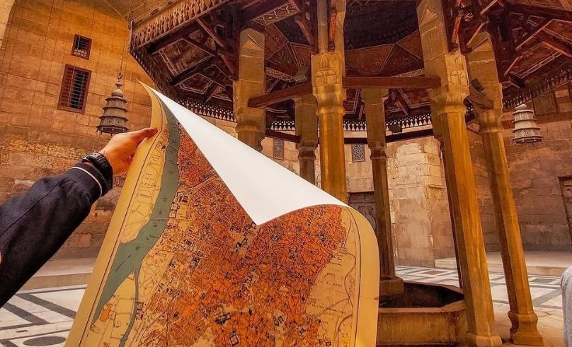
The map in Omar Marmoush’s hands shows Downtown Cairo in 1926. At its centre is Talaat Harb Square—or, as it was known then, Midan Soliman Pasha—where the bronze figure of Talaat Harb still presides over a city in flux, framed by Belle Époque facades that once defined Cairo’s cosmopolitan ambitions. Marmoush rolls it carefully and gestures at the street in front of him—a chaos of traffic and pedestrians with a hyper-modern sign plastered beneath a crumbling historic facade. “This is what maps do,” he tells me. “They carry the worldview of the people who made them. They reveal how a city was imagined, how borders were drawn, and how landscapes were interpreted at a specific moment in time.” Marmoush is the founder of Kharita, a Cairo-based initiative born out of Marmoush’s childhood fascination with borders and those who get to draw them. Dedicated to preserving, interpreting, and sharing historical maps of Egypt and the Middle East, Kharita functions both as an archive and a series of map-guided tours through the capital. And it was on one of those cartographic expeditions around Downtown that Marmoush first told me about a childhood spent moving through different countries and cultures because of his parents’ diplomatic work. Back then, his father would sit him down with atlases and history books, a “quiet but important role” that led to a premature understanding that maps aren’t simply tools for navigation. “They tell stories of the people who shaped them. But only of you’re patient enough to unravel the script.” When he eventually moved back to Egypt, he felt a strong curiosity—almost a hunger—to understand the country more deeply. Cairo in particular. It was a city he had known before, but now he wanted to understand how it had grown, how its neighbourhoods had evolved. His solution was to find maps. Lots of maps. All the maps he could get his hands on. He tracked the layers of Cairo through historic bookshops, bustling markets, the unassuming stalls of street sellers. He began archiving, documenting, researching, and curating the maps he had been collecting. Then, in 2021, he decided to launch Kharita. “It all feels like it happened accidentally,” he muses, swapping one map for another in his bag. “But really, it was inevitable.” I ask him if there’s a single document that captures why he does what he does, and he recalls a rare Arabic map of the Arab League States, published in 1960 by Iraq’s Dar Al Khat Al Araby, The House of Arabic Calligraphy, a name that signals the care and artistry behind its production. “Visually, it was very striking. Rich colours, beautiful typography, adorned by the flags of fifteen Arab states.” Some of those flags have since changed, some represent countries that no longer exist in the same form. This single document captivated him, a discarded illustration that captured the politics of a region in constant turmoil, contested between conflicting ambitions and tension. “We see maps as windows to the past, each telling a unique story. By preserving these pieces, we keep the stories alive and pass them onto future generations.” That is exactly the reason Kharita started integrated map-guided tours, so people can experience the hidden stories of the city; to walk a street whose name has changed three times in a century, yet is still clustered with the same buildings. You walk alongside Marmoush, a map in hand, comparing what stands before you with what once was, noticing details otherwise missed. The preparations behind these tours, however, are far from simple. It begins with selecting an area, gathering all relevant maps, and arranging them in sequence so the changes start announcing themselves. They take to the streets the second the routes start making sense, looking to speak to the inhabitants in an effort to unearth tales that have never made it to print. “The idea is to create a space where people with shared curiosities can meet and connect. In many ways, building that community is just as important to us as the maps themselves.” As we reach our final stop in Azbakeya, where Marmoush helps me hunt my first map of the city, I ask him what surprises him most when comparing old Cairo with the one that stands today. “The biggest realisation isn’t really how much has changed over decades. It’s how familiar it still is.” He gestures at the street around us. “Streets, landmarks, even alleyways that appeared on maps over a century ago still continue to shape everyday life.” He talks about the architecture that hasn’t been frozen, but adapted; centuries-old buildings now housing shops, offices, and families. “It makes you appreciate how we persist, how people continuously adapt to the city over time. Despite erosion and modern development, these spaces remain part of Cairo’s living heritage.” Then, rolling his map one last time, he tucks it under his arm, hands me a collection of stickers, and disappears into the traffic of the city he’s spent a lifetime learning to read.
- Previous Article This Hotel in Fez Was Once a 14th-Century Palace
- Next Article This Palace in Marrakech Feels Straight out of an Agatha Christie Book